
Plaza Italia uptown, Plaza Italia downtown
Column published in La Tercera, by Naim Bro, academic at the School of Government, Universidad Adolfo Ibáñez, and IMFD researcher
Last week, Plaza Italia underwent an important change: the seven lanes of the traditional roundabout were removed, giving way to an esplanade connecting Balmaceda, Forestal, and Bustamante parks. At the same time, the eternal controversy over which figure should occupy the center of the plaza resurfaced, following the removal of the statue of General Baquedano during the 2019 social uprising. Should the Baquedano statue be brought back? Should it be replaced with one of Gabriela Mistral?
That discussion brought me back to an old question: Is Plaza Italia still the dividing line of Santiago, as the saying goes, “Plaza Italia para arriba, Plaza Italia para abajo” (“above Plaza Italia, below Plaza Italia”)?
Some say no. Writer Roberto Merino argues that this dividing line has lost its meaning. Academic Ricardo Carrasco suggests that the dividing line has shifted toward Tobalaba, around the Mercado Urbano Tobalaba.
But I wanted to verify this more objectively, using data.
In data science, there is a technique called clustering. Imagine you have information about all the neighborhoods in a city: socioeconomic level, average age, proportion of migrants, perception of safety, land use, distribution of surnames, etc. An algorithm can identify which areas are similar to each other and group them together.
That is what I did. I gathered data from different sources:
• The aesthetic characteristics at different points across the city (with data obtained from Rossetti et al 2019), such as how beautiful, safe, and vibrant a neighborhood looks (Thanks to Hans Lobel – co-author of the study – for providing me with the data)
• Demographic information from the 2017 census (socioeconomic level, age, gender, and migration status)
• The distribution of surnames by neighborhood, with data from Bro & Mendoza 2021.
• Land use according to SII records, obtained from Vera et al 2022.
Then, an algorithm (for the nerds out there: Gaussian Mixture Model) grouped the neighborhoods into three major zones based on their similarity across these indicators. In the maps below, you can see what the main types of neighborhoods in Santiago are.
Figure 1: Maps with the city of Santiago grouped according to different types of data
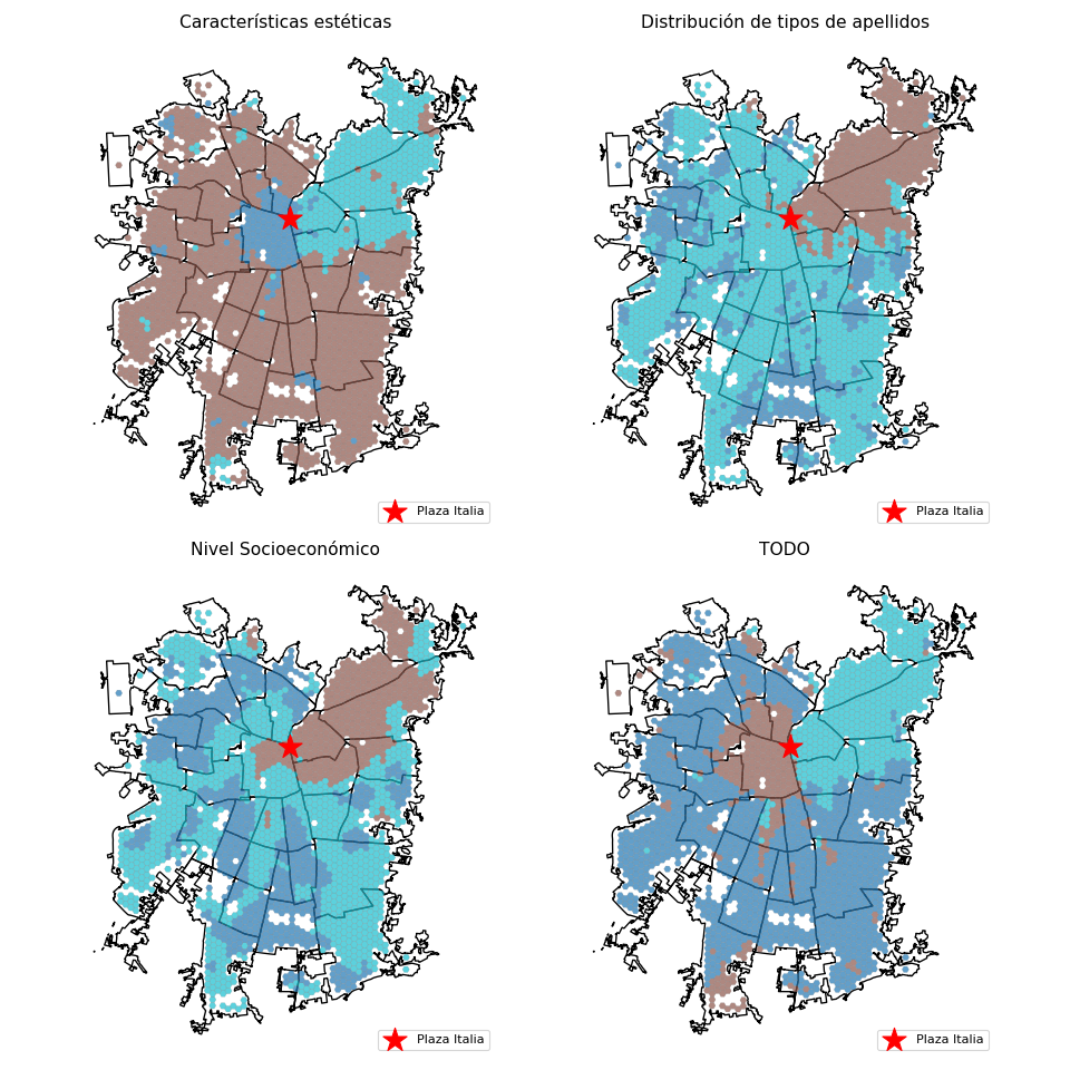
What do these maps tell us? The story changes a bit depending on which indicator you use, but the overall pattern is clear: there are three Santiagos. Downtown, the upscale neighborhoods, and the deep Santiago.
• Downtown (Santiago Centro and surrounding areas) is perceived as vibrant but also unsafe and with depressing areas. It shows a strong contrast between historic buildings and deteriorated spaces. In social terms, it is the sector with the highest proportion of migrants, the youngest population, and a slightly lower proportion of women. The data shows that it plays the role of an “arrival city”: it is the most intensely commercial area of the city, with the highest concentration of hotels, offices, and public administration buildings.
• The upscale neighborhoods (from Plaza Italia upward) are perceived as the most beautiful and affluent area of the city. It has the highest proportion of elite surnames and few Mapuche surnames. Its population is slightly more female and older, and it has an intermediate proportion of migrants. Economically, its average socioeconomic level far exceeds that of the rest of Santiago. Its land use is mixed, combining residential areas with some commerce, offices, and parking lots.
• The deep Santiago, which groups together more peripheral and residential districts, shows intermediate attributes. It is perceived as less beautiful, less safe, and less vibrant, but also as more residential. It has a higher proportion of Mapuche surnames, low levels of international migration, and its main function is that of a bedroom community: by far, residential is the most common land use, with little commercial or administrative activity.
And yes, Plaza Italia remains a real dividing line. Not just symbolic: the data also shows that one type of city ends there and another, very different one, begins. I am glad I am not the one who has to decide which statue should stand in the new Plaza Italia.